|
In grateful
appreciation to:
Bob Grigg
Curator:
Colebrook Historical
Society
Municipal Historian:
Town of Colebrook,
County of Litchfield,
State of Connecticut, USA
"It did exist however, in the fertile minds of various newspapermen who
undoubtedly generated additional sales and a following of several
generations of our forefathers..."
 |
Here is perhaps the one
topic that elicits more interest than
any other in the
entire history of the town of Colebrook.
Every one of us who grew up in town were
introduced to the topic at an early age, and those who moved here weren’t
residents very long before being “bitten by the bug,” whereupon they sought
out any scrap of information that they could uncover on the subject. It
didn’t take long, however, to discover that there weren’t really many facts,
but rather many stories, some of which were contradictory. It certainly
isn’t difficult to find someone in town who is willing to tell you their
particular set of “facts” as they know them. I’m going to start at the
beginning and tell you my observations on the subject.
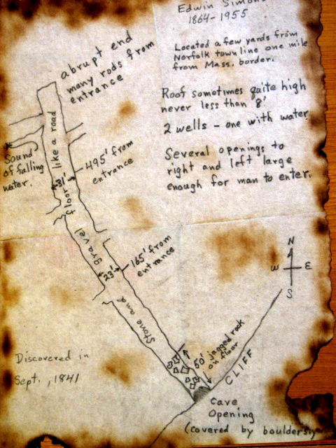
Ed
Simonds (1864-1956) was the first to tell me about the cave. The facts
as he understood them were as follows: A group of youths in the late
summer of 1841 decided to “have an adventure,” and somehow or other found
their way to Colebrook, where they had heard rumors concerning a large cave.
The results of their outing were published in a Norwich, Connecticut
newspaper dated September 24, 1841. In those days, it is a safe bet
that few readers lived outside the circulation area of the local paper;
hence the chances of this or any other local story being seen at any
distance was slight. This letter resurfaced in a book entitled
“American Adventure,” a compilation of adventure stories written about the
New England area. Harper Brothers subsequently published this in 1868.
This prominent publishing house guaranteed wide circulation, and undoubtedly
someone in the local area obtained a copy. It wouldn’t have been long
before someone organized an expedition to rediscover this local attraction.
Ed believed in the existence of the cave, but told me that the closest he
had come to it was one summer in his youth, while working for a surveyor,
their work took them over the top of the cliff situated above the entrance
to the cave, then covered by large boulders.
The
1868 book sparked renewed interest in town, resulting in further accounts of
searching for (and in some cases) finding and writing about the elusive
cave. This took place during the publishing reign of the Mountain
Times, a weekly newspaper that preceded the daily Winsted Citizen, which
made its début in 1888. It was the latter paper that published a series of
accounts, spaced about a generation apart, concerning the elusive Colebrook
Cave. During the 1920s, a period of time when Frank L. Wentworth was writing
locally, the topic really took on a new and larger aspect, and the editor of
the Citizen capitalized upon the creative writing of Wentworth, knowing the
value of hype in increasing public interest (and sales). Whatever it took to
increase sales, he was right there. In addition to the articles in the
Citizen, Wentworth authored several books about local lore, such as The
Winsted Wildman. If you believe that story as being the verbatim truth, I
have a document I will sell you giving title to the Colebrook River Dam (and
for a reasonable price, too).
It
was during the 1920s that several local men and youths scoured the wooded
hillside lying north of Shantry Road and west of the Phelps’ buildings in
North Colebrook. They claimed to have found the site and even explored the
cave for a distance of 50 feet before running low on matches. This was duly
reported in the Winsted Citizen on Nov. 19, 1926. One week later the Citizen
carried another article stating that a dozen or more men revisited the cave
site, but this time were only able to penetrate it to a depth of 80 or 100
feet, whereas the group the previous week claimed to have reached 30 rods
(495 feet). There is a major inconsistency here- the previous week’s account
clearly stated 50 feet as the depth to which they were able to penetrate.
Another episode in the periodic interest in the cave occurred in 1947, when
the Citizen again reported that youths representing several Colebrook
families spent the better part of a day combing the area generally agreed
upon to be its location, only to come up empty handed.
Alan
DeLarm, in his book Colebrook Stories, written in1979, devotes almost 6
pages to the topic. One weakness in this account is that some of the
articles quoted from are not dated, and I’m fairly certain, based in part on
Ed Simons’ account, that some stories consist of a hodge-podge of various
articles written at widely separated times.
Let’s
go back and take a closer look at what we know.
The
earliest account occurs in 1841, in a newspaper located in the southeast
corner of the state. This period of time marks the era of expansion in the
United States; the era of the turnpike, begun in the 1790s, had been
challenged first by the canals, then by the iron horse. It was then that the
railroad came as far north as Winsted, allowing for the first time
convenient travel from places as far distant as Norwich, Connecticut, for
example, in the space of a day or two. The era of exploration, begun in the
17th century, offered fewer and fewer challenges, at least east of the
Appalachians. If the urge was strong enough, there was the west, known, but
hardly tamed in the early 1840s. At the end of the decade, Sutter’s mill in
California would cease producing lumber and would initiate the great gold
rush that would change the political and demographic face of North America
forever.
Many
people, not wishing to journey so far afield, sought to discover interesting
sites closer to home overlooked by their predecessors. Of course, there were
many legitimate examples that came to light, but there were also cases where
much recklessness of the truth was foisted upon a gullible public. My
personal feeling is that we are confronted with the latter situation. I
don’t say this lightly, because I really want to believe in the Colebrook
Cave, but my interpretation of the facts as I see them state otherwise.
Beginning with the location: There seems to be a general agreement as to its
being located at the base of a hill just east of the Norfolk town line. Some
place it on land belonging to the descendants of Arah Phelps, just west of
Brummagem Brook, others say a little more to the south on land closer to
Shantry Road on Lossin property. At any rate, both locations consist of
talus slopes made up of large, jumbled boulders situated below steep granite
ledges.
The
1841 account describes the physical attributes of the cave as follows: the
opening lies at the base of a cliff. The first 50 feet consists of jagged
rock covering the floor, after which the floor is of stone and gravel much
like a road. The roof is sometimes quite high, never less than 8 feet. At a
distance of 165 feet, the width is 23 feet; at 495 feet, it is 31 feet high.
It comes to an abrupt end many rods from the entrance. There are two wells,
one with water, also there are several openings to the right and left, large
enough for a man to enter; the sound of falling water could be heard from
one of them near the far end.
The
description that appeared in the Citizen in 1926 stated the length as being
a quarter of a mile long (1320 feet), and being over 80 feet wide at one
place. Also it contained several deep caverns and recesses, with pools of
water and a stream of running water in it. Having said all this, they go on
to say that they did not explore more than 50 feet, as it was very spooky,
dark and damp, and their matches kept going out in the damp air. The
descriptive terminology used in these newspaper accounts are written so as
to elicit interest in the readers. Hints of possible animals (presumably
large carnivores), skeletons, precipitous cliffs containing huge boulders
hanging over the explorer’s head with no visible means of support all lend
an air of great adventure.
 Another newspaper account cited by DeLarm is undated, but contains the term
“macadamized” when describing the nature of the floor, which tells me it
also is most likely from the 1920s. The reporter claims to have borrowed a
lantern from one of the twenty some-odd people standing around outside, and
joined those inside the cave. He states that if all the fallen rocks that
blocked the entrance were removed, the cave opening would be 50 feet wide
and 30 feet high. At 165 feet he found the width to be 83 feet, and again at
495 feet determined that the width was 67 feet. He describes the walls as
being so smooth that they appeared to have been chiseled; the ceiling in
places was very high, never less than 10 feet. Another newspaper account cited by DeLarm is undated, but contains the term
“macadamized” when describing the nature of the floor, which tells me it
also is most likely from the 1920s. The reporter claims to have borrowed a
lantern from one of the twenty some-odd people standing around outside, and
joined those inside the cave. He states that if all the fallen rocks that
blocked the entrance were removed, the cave opening would be 50 feet wide
and 30 feet high. At 165 feet he found the width to be 83 feet, and again at
495 feet determined that the width was 67 feet. He describes the walls as
being so smooth that they appeared to have been chiseled; the ceiling in
places was very high, never less than 10 feet.
There
is one thread of continuity throughout its history, namely that all the
accounts (that I have seen, at least) are newspaper articles, all of which
were written in a tone calculated to excite the interest of the public. In
most cases, subsequent stories outdid its predecessor in descriptive
terminology. In 1841 certain measurements are given as to widths and heights
at specific depths; the first 50 feet consisting of jagged rock, at 165 feet
the width was given as 23 feet, at 30 rods (495 feet) the width was 23 feet.
They failed, however, to give any estimation as to its depth, simply stating
that it ended abruptly many rods from the entrance. Bear in mind however,
that nothing further is described after the 495-foot figure. And why should
all of these accounts use the same measurements in a dark cave having such
high humidity that the matches and lanterns kept going out? Under the
circumstances it would have been difficult at best to do any measurements,
let alone use the exact measurements (165 feet, 495 feet) as the previous
explorer.
By
the 1920s, the length has become one quarter of a mile (1320 feet), at the
depth of 165 feet the width is given as 83 feet and at the same 495-foot
mark, the width was reported as 67 feet. The minimum height of the ceiling
has increased from 8 feet to 10 feet. No two accounts describing the
rock-covered entrance ever agree, even those separated by one week. When
local boys returned home with their tales of adventure, their fathers are
told when they went to investigate that there must have been a recent
rockslide that now effectively blocks the entrance. Some accounts in the
early 20th century hint that local men had blasted the mouth of the cave
shut to protect society from the dangers that lurked within. Ted Vaill of
the Citizen wrote in 1947 that he had been informed by someone in his
audience that the entrance had been closed up by dynamiting a dozen or so
years before by the WPA (Works Project Administration – one of President
Roosevelt’s creations designed to lift the country out of the Great
Depression.) I really doubt that, mainly because no Colebrook land owner
ever was contacted by that or any other agency for permission to do any
blasting, as they were required to do. I even remember “the CCC Boys” asking
my parent’s permission to walk on our farm searching for wild currants to
destroy, because they could be a carrier of a blight known as Pine Rust,
which devastated White Pine trees.
My
thesis that the role of newspaper reporters plays a prominent part can be
taken a step further at this point, as Ted Vaill’s account, in attempting to
give specific directions on the whereabouts of the cave, states that it is
“in the same vicinity as Colebrook’s famed dinosaur tracks can be seen”.
Having broached the subject, let me say that what Ted was alluding to are
depressions in outcroppings of granitic schist having examples of what
geologists refer to as differential erosion, namely the weathering out of
softer stone surrounded by a harder matrix. One other example of this type
of erosion occurs at the swimming area known as Flat Rock in Colebrook
River. These depressions were called “the Devil’s footprints”. They do, for
all the world, look as though something with cloven hooves had walked over
soft mud that then solidified. The only problem is that granite schist does
not allow for the presence of fossils, and that is the only type of bedrock
we have in Colebrook. The overburden left by the glacier, to my knowledge,
consists of materials devoid of any type of fossils.
For
my final, and strongest argument as to my belief that no cave having the
characteristics attributed to Colebrook’s exists, I’m going to give you a
short (and hopefully clear) lesson in geology.
The
northwest corner of Connecticut, beginning at the western shore of
Barkhamsted Reservoir and progressing southwest to a point near Torrington,
then northwest so as to encompass Norfolk, and on into Massachusetts, forms
a triangle that contains the oldest geological formations in the state
(probably in the neighborhood of one billion years). It consists of rock
known as gneiss (pronounced “nice”) and schist. These are both members of a
family of rock called “igneous”, formed from molten material deep within the
Earth. They have subsequently been subjected to great pressure and
additional heat that gives a banded appearance when erosion eventually
exposes them on the surface. What we see today as we look at our landscape
is comparable to a snapshot in time of the never-ending process known as
erosion, the term we use to describe the process of chemical and mechanical
breakdown of any material that happens to be elevated over its neighbor.
Millions of years ago, when our present-day surface lay five to seven miles
below the surface, there occurred a truly cataclysmic event caused by the
collision of what is today Europe and Africa with present-day North America.
Connecticut was centered on the collision point. The titanic pressures our
native rock was subjected to resulted in the gneisses and schists. These
rocks do not and cannot contain fossils, nor do they harbor large empty
spaces known as caves
There
is another type of rock however, which can contain caves. These formations
were created on the bottoms of ancient oceans by the slow deposition of
shells and skeletons from deceased marine life, as well as fine silts and muds being eroded from land areas. If, after millions of years, mechanical
movements within the earth elevate these old ocean floors, it sometimes
creates an environment that allows groundwater to percolate downward,
dissolving softer regions and creating what we call caves. The depths of
some of these marine deposits are amazing; for example in the area
immediately south of Albany, New York, they reach 13,000 feet. This material
eroded westward from what is now western New England, which was home to a
range of mountains rivaling today’s Himalayas. Incidentally, there are many
large caverns in the Albany area, most of which are not commercial. I was an
avid spelunker while in college, and spent many a weekend exploring
seemingly endless passageways over there.
Unfortunately for Colebrook, we never had an ocean or even a shallow sea
over our territory, hence no marine deposits that could ever harbor caves.
Therefore, sadly, (and I truly mean that), the original 1841 description, as
well as subsequent embellishments, are of a classic limestone, or perhaps
mudstone cave – the flat floor, smooth sides, side passages, sounds of
falling or running water and the extreme humidity. The only embellishments
they overlooked were stalactites and stalagmites! It did exist however, in
the fertile minds of various newspapermen who undoubtedly generated
additional sales and a following of several generations of our forefathers
(and contemporaries).
- Bob Grigg
View/Print PDF
Below is a link
to another account of the Colebrook Cave on the web:
http://strangene.com/legends/colebrook.htm
- Back to
Index - |
|